Geography past questions: JAMB UTME 2021
71 objective questions, with answers. Free to read and practise.
Sit this paper
71 questions, one at a time, marked as you go or at the end. No account needed.
- 1._______ is defined as the total surrounding or medium of any organism in a given area
- A.Biotic component
- B.Abiotic component
- C.Environment
- D.Ecosystem
Show answerHide answer
Answer: C Environment
- 2._______ is the condition of the lower atmosphere of a place over a short period
- A.climate
- B.weather
- C.cloud
- D.humidity
Show answerHide answer
Answer: B weather
- 3.__________ is a highland area which seperates the headstreams of rivers flowing in different directions but rising from the same mountainous source
- A.flood plain
- B.cuesta
- C.watershed
- D.plateau
Show answerHide answer
Answer: C watershed
- 4.___________ is a layer of very fine wind-deposited sand and silt?
- A.loess
- B.seif
- C.barchan
- D.bajada
Show answerHide answer
Answer: A loess
- 5.________is the failure of the end point of a closed traverse to fall exactly on the point of origin of the transverse
- A.Error of compass
- B.Traverse error
- C.Error of closure
- D.Field error
Show answerHide answer
Answer: C Error of closure
- 6.A device for transferring information from analogue map into computer for further manipulation is
- A.Aerial photograph
- B.Digitizer
- C.Global positioning system
- D.Plotter
Show answerHide answer
Answer: B Digitizer
- 7.A settlement located where two rivers meet is called a
- A.nucleated settlement
- B.confluence town
- C.linear settlement
- D.nodal town
Show answerHide answer
Answer: B confluence town
- 8.An example of a coastline of emergence is
- A.a raised beach
- B.an estuarian coast
- C.a dalmatian coast
- D.a ria coast
Show answerHide answer
Answer: A a raised beach
- 9.Cement factory is usually located near
- A.Source of capital
- B.Source of labour
- C.Source of raw material
- D.The market
Show answerHide answer
Answer: C Source of raw material
- 10.Geo-referencing in GIS is referred to as
- A.Assigning spatials location to a data
- B.Data acquisition
- C.Data Management
- D.Manipulation and analysis
Show answerHide answer
Answer: A Assigning spatials location to a data
- 11.If the scale of a map is 2cm to 1km, what is the ground distance if the distance between two towns on the map is 20cm
- A.5km
- B.2.5km
- C.10km
- D.20km
Show answerHide answer
Answer: B 2.5km
- 12.If the scale of two maps are (a;1:100,000 and b;1:400,000) what is the ground distance if the distance between two towns on the maps is 10cm
- A.10km, 40km
- B.5km, 20km
- C.2.5km, 10km
- D.20km, 80km
Show answerHide answer
Answer: A 10km, 40km
- 13.In a combined maximum and minimum thermometer, the difference between the hottest and coldest daily temperature for that day gives the
- A.Diurnal range of temperature
- B.Mean daily temperature
- C.Minimum daily temperature
- D.Maximum daily temperature
Show answerHide answer
Answer: A Diurnal range of temperature
- 14.In Nigeria, which of the following vegetation zones is best known for timber exploitation?
- A.Fresh water swamp forest
- B.Fresh water swamp forest
- C.Montane vegetation
- D.Rain forest
Show answerHide answer
Answer: D Rain forest
- 15.In the desert region the most prominent agent of erosion is
- A.Thunder storms
- B.Rain fall
- C.Rivers
- D.Wind
Show answerHide answer
Answer: D Wind
- 16.Jos plateau is an example of a
- A.Volcanic plateau
- B.Dissected plateau
- C.Tectonic plateau
- D.Bassalt Plateau
Show answerHide answer
Answer: A Volcanic plateau
- 17.Kossou Dam is located on River
- A.Volta
- B.Bandama
- C.Ginene
- D.Nile
Show answerHide answer
Answer: B Bandama
- 18.Nigeria is located between longitudes
- A.3°E and 15°E
- B.2°E and 15°E
- C.1°E and 10°E
- D.3°E and 10°E
Show answerHide answer
Answer: A 3°E and 15°E
- 19.Nigeria's major export commodity is
- A.Coal
- B.Cocoa
- C.Cotton
- D.Petroleum
Show answerHide answer
Answer: D Petroleum
- 20.One of the disadvantages of water transport is that it
- A.causes atmospheric pollution
- B.is used for carrying agricultural commodities only
- C.is not flexible
- D.cannot carry bulky goods
Show answerHide answer
Answer: A causes atmospheric pollution
- 21.One of the following is not a problem involved in harnessing solar energy?
- A.Poor technological know-how
- B.Adequacy of capital
- C.Unreliability
- D.Fear of competition with established energy sources
Show answerHide answer
Answer: B Adequacy of capital
- 22.One of the following surveying instruments is used to set out lines at right angles to the main chain line
- A.Optical square
- B.Station pegs
- C.Offset staff
- D.Steel Band
Show answerHide answer
Answer: A Optical square
- 23.River regime is best described as the
- A.rate at which a river flows
- B.seasonal variation in the volume of water in a river
- C.period a river overflows its banks
- D.amount of load a river carries
Show answerHide answer
Answer: B seasonal variation in the volume of water in a river
- 24.Sparse population in the middle belt of Nigeria can not be attributed to
- A.Absence of major industries
- B.Absence of major minerals
- C.Poor soil
- D.Slave trade
Show answerHide answer
Answer: B Absence of major minerals
- 25.The benefits of international trade to developing nations include the following except
- A.Encourages specialisation in production
- B.Encourages healthy competition
- C.Strains international trade relation
- D.Enables nations to move from subsistence to mechanized economy
Show answerHide answer
Answer: C Strains international trade relation
- 26.The best solution to the rapid depletion of forest resources in West Africa is to
- A.reserve hectares of land for plantations
- B.Introduce forest conservation techniques
- C.Import wood from other countries
- D.Employ more forest guards
Show answerHide answer
Answer: B Introduce forest conservation techniques
- 27.The coastal regions of Sierra leonne record an annual rainfall of over
- A.3,000 mm
- B.4,000 mm
- C.5,000 mm
- D.6,500 mm
Show answerHide answer
Answer: B 4,000 mm
- 28.The correct arrangement of the layers of the earth crust from the surface to the interior is
- A.sial, mantle, sima, core
- B.sima, sial, core, mantle
- C.core, mantle, sima and sial
- D.sial, sima, mantle and core
Show answerHide answer
Answer: D sial, sima, mantle and core
- 29.The dam which is not used in the gezira is the
- A.A swan
- B.Sennar
- C.Roseires
- D.Jebel Azula
Show answerHide answer
Answer: C Roseires
- 30.The following are responsible for the concentration of industries in eastern United States of America except
- A.Large market
- B.Natural resources
- C.Inadequate capital
- D.High technology
Show answerHide answer
Answer: C Inadequate capital
- 31.The following are seaports used in the North Atlantic sea route except
- A.Lagos-Antwerp
- B.Lagos-Montreal
- C.Lagos-Southampton
- D.Lagos-Rotterdam
Show answerHide answer
Answer: B Lagos-Montreal
- 32.The following are the importance of highland in Nigeria except
- A.occupy good land
- B.settlement sites
- C.source of minerals
- D.source of rivers
Show answerHide answer
Answer: B settlement sites
- 33.The following are volcanic mountains except
- A.Cotopaxi of Ecuador
- B.Midcrop of Sumatra
- C.Fuji of Japan
- D.Monadnock of USA
Show answerHide answer
Answer: D Monadnock of USA
- 34.The function performed by urban to the rural settlement in supply of
- A.Industrial raw materials
- B.medicinal herbs
- C.food
- D.maufactured goods
Show answerHide answer
Answer: D maufactured goods
- 35.The human activity that can improve composition of the atmosphere is
- A.Use of chemicals
- B.Land reclamation
- C.Mining and Construction works
- D.Cutting down of trees
Show answerHide answer
Answer: A Use of chemicals
- 36.The outer structure of the earth is made up of the following except?
- A.mesosphere
- B.atmosphere
- C.biosphere
- D.Hydrosphere
Show answerHide answer
Answer: A mesosphere
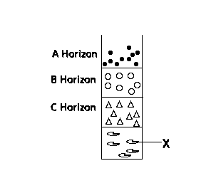
- 37.The part labelled X in the soil profile above is known as
- A.top soil
- B.sub soil
- C.parent materials
- D.bedrock
Show answerHide answer
Answer: D bedrock
- 38.The soil gains nitrogen through one of the following except
- A.Denitrification
- B.Application of organic manure
- C.Electrical discharge
- D.Symbiotic nitrogen fixation
Show answerHide answer
Answer: A Denitrification
- 39.The system of agriculture referred to as "Land rotation" is
- A.Bush fallow
- B.Crop rotation
- C.Mixed farming
- D.Shifting cultivation
Show answerHide answer
Answer: D Shifting cultivation
- 40.The tourist centre of Ogbunike care is located near
- A.Kainji in Niger state
- B.Yankari in Bauchi state
- C.Ikeja in Lagos state
- D.Onitsha in Anambra state
Show answerHide answer
Answer: D Onitsha in Anambra state
- 41.The type of water left in the soil after excess water has been drained off, following heavy rainfall is known as
- A.Field capacity
- B.Field capacity
- C.gravitational water
- D.hygroscopic water
Show answerHide answer
Answer: B Field capacity
- 42.These are areas of crude oil production in Nigeria except
- A.Afam
- B.Egbema
- C.Oloibiri
- D.Ughelli
Show answerHide answer
Answer: B Egbema
- 43.These are landforms producing agent except
- A.waves
- B.rivers
- C.storms
- D.glaciers
Show answerHide answer
Answer: C storms
- 44.Tropical savanna vegetation is characterized by
- A.drought - resistant trees
- B.trees with broad leaves and fleshy bark
- C.palm trees and thorny scrub
- D.scattered every green trees
Show answerHide answer
Answer: A drought - resistant trees
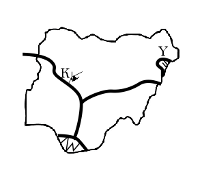
- 45.Use the map below to answer this question above The feature marked Y on the map is?
- A.obon hill
- B.obudu plateau
- C.alantika mountain
- D.mandara mountain
Show answerHide answer
Answer: D mandara mountain
- 46.Use the map below to answer this question above What is the feature labelled K on the map is
- A.river sokoto
- B.lake chad
- C.lake kainji
- D.river zamfara
Show answerHide answer
Answer: C lake kainji
- 47.What is the process of lowering and levelling of the earth surface by gradual breaking and wearing away of such earth's surfaces.
- A.Weathering
- B.Denudation
- C.Relief
- D.Mass wasting
Show answerHide answer
Answer: B Denudation
- 48.Where the salinity of an ocean is high;
- A.the ocean water is dense and flows at the ocean surface towards a low salinity area
- B.the ocean water is dense and creeps at the bottom of the ocean towards low salinity areas
- C.the ocean water is light and flows at the area surface towards a high salinity area
- D.the ocean water is light and flows at the ocean surface towards a low salinity area
Show answerHide answer
Answer: B the ocean water is dense and creeps at the bottom of the ocean towards low salinity areas
- 49.Which of the following countries is located in North Africa.
- A.Zaire
- B.Ruwanda
- C.Namibia
- D.Algeria
Show answerHide answer
Answer: D Algeria
- 50.Which of the following farming activity best describes the rearing of only animals like cattle, sheep and goat mainly in the savanna belt of the north?
- A.mixed farming
- B.animal farming
- C.pastoral farming
- D.intensive farming
Show answerHide answer
Answer: D intensive farming
- 51.Which of the following gives the correct full meaning of G.I.S?
- A.Geographic Internet Solution
- B.Geographic Internet System
- C.Geographic Information Spread
- D.Geographic Information System
Show answerHide answer
Answer: D Geographic Information System
- 52.Which of the following has the highest salinity
- A.south atlantic
- B.dead sea
- C.red sea
- D.Mediterranean Sea
Show answerHide answer
Answer: C red sea
- 53.Which of the following is a problem of landlocked countries
- A.security of goods
- B.political stability
- C.low freight cost
- D.political indepedence
Show answerHide answer
Answer: D political indepedence
- 54.Which of the following is a reason for the high volume of trade between Nigeria and developed countries?
- A.similarity of products
- B.low level of technology
- C.colonial Ties
- D.presence of trade unions
Show answerHide answer
Answer: C colonial Ties
- 55.Which of the following is a sedimentary rock.
- A.Graphite
- B.shale
- C.marble
- D.schist
Show answerHide answer
Answer: B shale
- 56.Which of the following is a way of controlling soil erosion
- A.Overgrazing
- B.Contour ploughing
- C.Deforestation
- D.Bush burning
Show answerHide answer
Answer: B Contour ploughing
- 57.Which of the following is an effect of the earth's revolution?
- A.Day and night
- B.It determines a year
- C.Dawn and Twilight
- D.Apparent Sunrise and sunset
Show answerHide answer
Answer: B It determines a year
- 58.Which of the following is an importance of the atmosphere to living organisms?
- A.It provides water for industrial uses
- B.It provides oxygen for animals and plants for respiration
- C.It provides shelter in form of timber for man
- D.It aids transportation through construction of roads and railways
Show answerHide answer
Answer: B It provides oxygen for animals and plants for respiration
- 59.Which of the following is associated with savanna vegetation
- A.Shallow - rooted trees
- B.Trees that grow throughout the year
- C.Scrub
- D.Dense vegetation
Show answerHide answer
Answer: C Scrub
- 60.Which of the following is not a factor that favours industrial concentration in Western Nigeria?
- A.Availability of raw materials
- B.Closeness to major importing and exporting ports
- C.Creativity of people in the area
- D.Good road network
Show answerHide answer
Answer: C Creativity of people in the area
- 61.Which of the following is not a graphical representation of statistical data?
- A.Choropleth map
- B.Dot map
- C.Shaded map
- D.Star graph
Show answerHide answer
Answer: C Shaded map
- 62.Which of the following is not an element of climate
- A.Attitude
- B.Temperature
- C.Air pressure
- D.Precipitation
Show answerHide answer
Answer: B Temperature
- 63.Which of the following is not caused by the earth's rotation?
- A.Day and night
- B.Seasonal changes
- C.Deflection of winds
- D.Deflection of ocean currents
Show answerHide answer
Answer: A Day and night
- 64.Which of the following lakes owes its origin mainly to faulting?
- A.Lake Chad
- B.Lake Superior
- C.Lake Malawi
- D.Lake Victoria
Show answerHide answer
Answer: C Lake Malawi
- 65.Which of the following processes leads to the loss of carbon from the air
- A.combustion
- B.combustion
- C.putrifaction
- D.photosynthesis
Show answerHide answer
Answer: D photosynthesis
- 66.Which of the following rocks is organically formed?
- A.Gypsum
- B.Coal
- C.Grit
- D.shale
Show answerHide answer
Answer: B Coal
- 67.Which of the following statements is true of the North Atlantic Sea route?
- A.It is the busiest sea route
- B.It links Nigeria with Europe
- C.Goods carried on the route include grains
- D.It links North America with Europe
Show answerHide answer
Answer: A It is the busiest sea route
- 68.Which of the following tourist centres is wrongly paired?
- A.Eiffel Tower - Germany
- B.Pyramids - Egypt
- C.The colosseum - Italy
- D.Victoria falls - Zambia
Show answerHide answer
Answer: A Eiffel Tower - Germany
- 69.Which of the following towns is not a precolonial town
- A.Ilorin
- B.Bida
- C.Enugu
- D.Ibadan
Show answerHide answer
Answer: C Enugu
- 70.Which of the following zones is the least industrialized in Nigeria?
- A.Lokoja - Ajaokuta
- B.Lagos - Ikeja
- C.Port harcourt - Aba
- D.Abeokuta - Ibadan
Show answerHide answer
Answer: D Abeokuta - Ibadan
- 71.Which statement is not true of the middle belt in Nigeria?
- A.The soil is not productive
- B.mineral resources can be found in it
- C.the population is sparse
- D.None of the above
Show answerHide answer
Answer: D None of the above
Printing is turned off here to protect the question bank. Get the SmarTest app to study offline.
More free Geography papers
JAMB Geography 1978–2020 is in the app
The latest five years of each paper are free here. The SmarTest app has every year we hold, a worked explanation for each answer, and timed mock exams. It works offline.
Android, Windows, Mac and Linux