Geography past questions: WAEC SSCE 2025
30 objective questions, with answers. Free to read and practise.
Sit this paper
30 questions, one at a time, marked as you go or at the end. No account needed.
- 1.A feature produced by water in desert areas is
- A.zeugens
- B.wadis
- C.barchans
- D.yardangs
Show answerHide answer
Answer: B wadis
- 2.All the following are man-made features found on the mapped area, except?
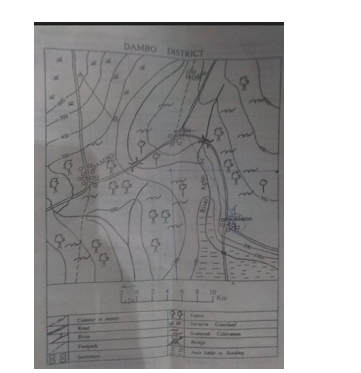
- A.settlements
- B.bridges
- C.dams
- D.roads
Show answerHide answer
Answer: C dams
- 3.Calculate the range of temperature for the station
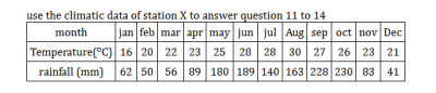
- A.2°C
- B.14°C
- C.5°C
- D.12C
Show answerHide answer
Answer: B 14°C
- 4.In Köppen's classification of climates, AF refers to
- A.desert
- B.mediterranean
- C.equatorial
- D.monsoon
Show answerHide answer
Answer: C equatorial
- 5.In the Northern Hemisphere, the summer solstice is experienced on
- A.march 21
- B.December 22
- C.june 21
- D.September 22/23
Show answerHide answer
Answer: C june 21
- 6.Line A - B in the mapped area can best be described as
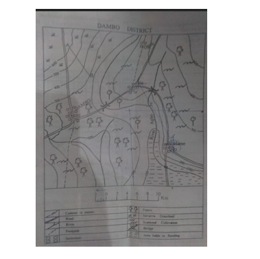
- A.convex slope
- B.uniform
- C.concave slope
- D.dip slope
Show answerHide answer
Answer: C concave slope
- 7.Marble is a metamorphosed
- A.gabbro
- B.granite
- C.basalt
- D.limestone
Show answerHide answer
Answer: D limestone
- 8.On March 21 each year, all towns in the Southern Hemisphere experience what?
- A.partial darkness
- B.longer period of twilight
- C.complete daylight for 14 hours
- D.equal lengths of day and night
Show answerHide answer
Answer: D equal lengths of day and night
- 9.The bearing of ILO from HUME is about
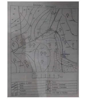
- A.145°
- B.35°
- C.210°
- D.330°
Show answerHide answer
Answer: D 330°
- 10.The direction of DAMBO and HUME is
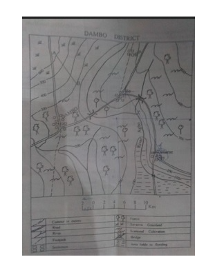
- A.southwest
- B.northwest
- C.southeast
- D.northeast
Show answerHide answer
Answer: B northwest
- 11.The distance between Dambo and Ogoh as the crow flies is approximately
- A.5.0km
- B.26.0km
- C.10.0km
- D.20.0km
Show answerHide answer
Answer: D 20.0km
- 12.The highest point of the mapped area is found in the
- A.southwest
- B.southeast
- C.northwest
- D.northeast
Show answerHide answer
Answer: C northwest
- 13.The longitudinal which almost bisects Africa into two halves, east and west, is longitude
- A.20°W
- B.20°E
- C.40°E
- D.40ºW
Show answerHide answer
Answer: B 20°E
- 14.The most popular means of transportation in the mapped area is
- A.footpath
- B.air
- C.river
- D.road
Show answerHide answer
Answer: D road
- 15.The rock that has the capacity to retain underground water is
- A.crystalline
- B.impermeable
- C.permeable
- D.compact
Show answerHide answer
Answer: C permeable
- 16.The scale of the map in representative fraction(RF) is
- A.1:50,000
- B.1:200,000
- C.1:150,000
- D.1:10,000
Show answerHide answer
Answer: B 1:200,000
- 17.The temperature reading at the peak of a volcano is 6°C. What will be the temperature at the foot of the volcano, which is 3000 meters above the surrounding lowland?
- A.25.5°C
- B.13.5°C
- C.36.5°C
- D.5.5°C
Show answerHide answer
Answer: A 25.5°C
- 18.The time at the Greenwich meridian is 10:00 a.m. What would the time be at 30ºc
- A.12.00 pm
- B.8.00am
- C.12.00am
- D.8.00pm
Show answerHide answer
Answer: A 12.00 pm
- 19.What is the annual rainfall for station X?
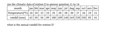
- A.1511mm
- B.1160mm
- C.1504mm
- D.1254mm
Show answerHide answer
Answer: A 1511mm
- 20.What is the time in Accra at longitude 0° when the local time at longitude 45°W is 12 noon?
- A.5pm
- B.7pm
- C.9pm
- D.3pm
Show answerHide answer
Answer: D 3pm
- 21.Which mountain type is described as the lighthouse of the Mediterranean?
- A.fold
- B.Block
- C.volcanic
- D.residual
Show answerHide answer
Answer: C volcanic
- 22.Which of the drainage patterns is best established in the areas of alternate hard and soft rocks?
- A.Radial
- B.centripetal
- C.Trellis
- D.Annular
Show answerHide answer
Answer: C Trellis
- 23.Which of the following are achievements of ECOWAS? i. common markets ii. free movement of people iii. military cooperation iv. trade restriction
- A.i, iii and iv only
- B.i, ii and iii only
- C.i, ii and iv only
- D.ii, iii and iv only
Show answerHide answer
Answer: B i, ii and iii only
- 24.Which of the following are possible causes of soil erosion? i. bush burning ii. overgrazing iii. reafforestation iv. excavation
- A.i,ii and iv only
- B.ii,iii and iv only
- C.i and ii only
- D.i,ii and iii only
Show answerHide answer
Answer: A i,ii and iv only
- 25.Which of the following elements of weather is matched with the wrong measuring instrument?
- A.Humidity and barometer
- B.Rainfall and rain gauge
- C.sunshine and sundial
- D.wind-speed and anemometer
Show answerHide answer
Answer: A Humidity and barometer
- 26.Which of the following is a deposition feature of an arid region?
- A.rock pedestal
- B.Barchan
- C.zeugen
- D.yardang
Show answerHide answer
Answer: B Barchan
- 27.Which of the following pairs of landforms are of desert origin ?
- A.Barchans and tombolos
- B.sandbars and tombolos
- C.Zuegens and inselbergs
- D.yardangs and batholiths
Show answerHide answer
Answer: C Zuegens and inselbergs
- 28.Which of the following pairs of minerals are from the bulk of the inner core of the Earth?
- A.silicon and copper
- B.Aluminium and iron
- C.iron and Nickel
- D.tin and columbite
Show answerHide answer
Answer: C iron and Nickel
- 29.Which of the following statements is true about station X?

- A.The station has double maxima rainfall
- B.The rainfall duration is six months
- C.rain mainly falls in winter
- D.The rainfall in the station is uniformly distributed over the months
Show answerHide answer
Answer: A The station has double maxima rainfall
- 30.Which of the following wave actions is a process of erosion?
- A.traction
- B.saltation
- C.hydraulic
- D.suspension
Show answerHide answer
Answer: C hydraulic
Printing is turned off here to protect the question bank. Get the SmarTest app to study offline.
More free Geography papers
WAEC Geography 1988–2020 is in the app
The latest five years of each paper are free here. The SmarTest app has every year we hold, a worked explanation for each answer, and timed mock exams. It works offline.
Android, Windows, Mac and Linux