Geography past questions: JAMB UTME 2025
75 objective questions, with answers. Free to read and practise.
Sit this paper
75 questions, one at a time, marked as you go or at the end. No account needed.
- 1.[see linked page: question refers to shared diagram/text above]
- A.the sun to revolve around its orbit
- B.the moon to revolve once around the earth
- C.the earth to revolve once round the sun
- D.the earth to rotate on its axis
Show answerHide answer
Answer: C the earth to revolve once round the sun
- 2.A block mountain is formed as a result of
- A.differential erosion
- B.faulting
- C.fissure
- D.vulcanicity
Show answerHide answer
Answer: B faulting
- 3.A feature produced by water in desert areas is
- A.barchans
- B.yardangs
- C.wadis
- D.zeugens
Show answerHide answer
Answer: C wadis
- 4.A fog is most likely to develop when a
- A.warm moist wind blows over a cold current
- B.cold, dry winds blows over a warm current
- C.warm moist wind blows over a warm current
- D.warm, dry winds blows over a cold current
Show answerHide answer
Answer: A warm moist wind blows over a cold current
- 5.A typical example of landforms produced by marine erosion is a
- A.stack
- B.spit
- C.beach
- D.mud-flat
Show answerHide answer
Answer: A stack
- 6.An example fossil fuel is
- A.coal
- B.clay
- C.granite
- D.sandstone
Show answerHide answer
Answer: A coal
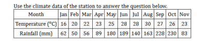
- 7.Calculate the range of temperature for the station
- A.5°C
- B.12°C
- C.14°C
- D.2°C
Show answerHide answer
Answer: C 14°C
- 8.Great Britain and Germany are trading partners of West African countries from
- A.South America
- B.The Far East
- C.West Europe
- D.North America
Show answerHide answer
Answer: C West Europe
- 9.How were the major mountain belts of the world produced? [ ]
- A.By wind erosion
- B.By glacial erosion
- C.By Folding
- D.By weathering
Show answerHide answer
Answer: C By Folding
- 10.If a map at a scale of 1:50,000 is reduced by half, what is the new scale of the map?
- A.1:100,000
- B.1:25,000
- C.1:200,000
- D.1:250,000
Show answerHide answer
Answer: B 1:25,000
- 11.In which of the following countries is commercial grain farming an important occupation?
- A.Spain
- B.Canada
- C.Kenya
- D.Nigeria
Show answerHide answer
Answer: B Canada
- 12.Industries are broadly classified into
- A.primary, secondary, and tertiary
- B.fishing, mining, and food processing
- C.mining, furniture making, and cocoa processing
- D.primary, secondary, and manufacturing
Show answerHide answer
Answer: A primary, secondary, and tertiary
- 13.Inter-regional trade between countries in West Africa is promoted mainly by
- A.competition among the nations in Africa
- B.production of similar goods
- C.deliberate government policies in recent times
- D.relationship with former colonial rulers
Show answerHide answer
Answer: C deliberate government policies in recent times
- 14.Mixed farming implies
- A.growing crops and rearing animals on a given land area
- B.growing grains and root crops on the same piece of land
- C.keeping poultry and rearing pigs on one and the same farm
- D.mixed cultivation of wheat, barley, and oats
Show answerHide answer
Answer: A growing crops and rearing animals on a given land area
- 15.More Hydroelectric Power projects should be constructed in Tropical Africa because
- A.skilled labour is scarce
- B.there are absence of waterfalls on rivers
- C.there is an increasing demand for power
- D.there is scanty rainfall
Show answerHide answer
Answer: C there is an increasing demand for power
- 16.On a population map of the world, all but one of the following appear generally as regions of low population density
- A.The Island of Java
- B.The Amazon forests
- C.The hot deserts
- D.Antarctica
Show answerHide answer
Answer: A The Island of Java
- 17.On March 21 each year, all towns in the southern hemisphere experience?
- A.longer period of twilight
- B.complete daylight for 14hours
- C.equal length of day and night
- D.partial darkness
Show answerHide answer
Answer: C equal length of day and night
- 18.Pick out the incorrect statement
- A.Scandinavia is noted for its hardwood timber
- B.The North Sea is a great fishing area
- C.Katanga is a copper mining region
- D.The Ruhr is a great industrial region
Show answerHide answer
Answer: A Scandinavia is noted for its hardwood timber
- 19.Smooth oval hills composed mainly of boulders or glacial sands and gravels are known as
- A.arêtes
- B.drumlins
- C.moraines
- D.eskers
Show answerHide answer
Answer: B drumlins
- 20.Temperature is to isotherms as air pressure is to
- A.isobars
- B.isopleths
- C.isolines
- D.contours
Show answerHide answer
Answer: A isobars
- 21.The greatest volume of shipping across the Atlantic Ocean is
- A.between Europe and North America
- B.between Africa and South America
- C.between Africa and North America
- D.between North America and South America
Show answerHide answer
Answer: A between Europe and North America
- 22.The heavy, dark soil associated with floodable valley bottoms is a
- A.lateritic soil
- B.hydromorphic soil
- C.ferrallitic soil
- D.podzolic soil
Show answerHide answer
Answer: B hydromorphic soil
- 23.The industrial belt of Japan produces
- A.ships, electronics, and motor vehicles
- B.warships, ammunitions, and building materials
- C.fertilizers, pesticides, and combined harvesters
- D.leather goods, plastic, and pharmaceutical products
Show answerHide answer
Answer: A ships, electronics, and motor vehicles
- 24.The longitude, which almost bisects Africa into two equal halves, east and west, is longitude
- A.20°E
- B.20°W
- C.40°E
- D.40°W
Show answerHide answer
Answer: A 20°E
- 25.The main advantage of the chain survey over the prismatic compass survey is that the former
- A.does not require a base map
- B.yields relatively more accurate results
- C.closes its boundaries with no correction
- D.involves highly more portable equipment
Show answerHide answer
Answer: B yields relatively more accurate results
- 26.The main use of the Abney Level in surveying is to determine the
- A.angle of inclination
- B.area coverage
- C.spot height
- D.relative location
Show answerHide answer
Answer: A angle of inclination
- 27.The most common form of migration experienced in countries of Tropical Africa is.
- A.urban-urban migration
- B.rural-urban migration
- C.rural-rural migration
- D.urban-rural migration
Show answerHide answer
Answer: B rural-urban migration
- 28.The most significant factor which accounts for the rapid growth in the population of the capital cities of West Africa is
- A.political rallies
- B.sport events
- C.rural-urban migration
- D.religious tourism
Show answerHide answer
Answer: C rural-urban migration
- 29.The rock which has the capacity to retain underground water is?
- A.compact
- B.permeable
- C.crystalline
- D.impermeable
Show answerHide answer
Answer: B permeable
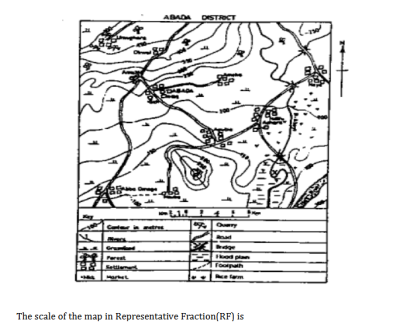
- 30.The scale of the map in representative fraction(RF) is
- A.1:100,000
- B.1:50,000
- C.1:25,000
- D.1:200,000
Show answerHide answer
Answer: B 1:50,000
- 31.The sun is overhead at the tropic of Capricorn on
- A.June 21
- B.December 22
- C.September 23
- D.March 21
Show answerHide answer
Answer: B December 22
- 32.The temperature reading at the peak of a volcano is 6ºC. What will be the temperature at the foot of the volcano, which is 3000 metres from the surrounding low land?
- A.25.5°C
- B.13.5°C
- C.23.5°C
- D.5.5°C
Show answerHide answer
Answer: A 25.5°C
- 33.The vegetation of the warm Temperate Eastern Margin is characterized by
- A.evergreen shrubs and thickets
- B.mixed coniferous and broad-leaved evergreen forests
- C.mixed deciduous and coniferous forests
- D.mixed tropical rainforests and monsoonal forests
Show answerHide answer
Answer: D mixed tropical rainforests and monsoonal forests
- 34.The wearing away of the sides and bottom of a river's channel is called
- A.attrition
- B.corrosion action
- C.corrosion
- D.hydraulic action
Show answerHide answer
Answer: D hydraulic action
- 35.Two factors that promote rapid chemical weathering in the tropics are
- A.high temperature and high humidity
- B.low temperature and high humidity
- C.high temperature and extreme aridity
- D.high temperature and low humidity
Show answerHide answer
Answer: A high temperature and high humidity
- 36.Urban floods are mainly caused by
- A.blockage of drains and waterways
- B.clearance of vegetation on farmlands
- C.construction of dams and barrages
- D.establishment of shelter belts
Show answerHide answer
Answer: A blockage of drains and waterways
- 37.What does subsistence agriculture mean?
- A.Agricultural production for household consumption
- B.Agricultural production for cash
- C.Extensive agriculture
- D.Intensive agriculture
Show answerHide answer
Answer: A Agricultural production for household consumption
- 38.What is the annual rainfall for station X?
- A.1160 mm
- B.1461 mm
- C.1504 mm
- D.1511 mm
Show answerHide answer
Answer: D 1511 mm
- 39.What is the highest contour line in the mapped area?
- A.400 metres
- B.600 metres
- C.500 metres
- D.300 metres
Show answerHide answer
Answer: A 400 metres
- 40.What is the population density of a country with a total population of 140,000,000 and a total land area of 500,000 km \(^2\) ?
- A.200 persons per km \(^2\)
- B.350 persons per km \(^2\)
- C.280 persons per km \(^2\)
- D.500 persons per km \(^2\)
Show answerHide answer
Answer: C 280 persons per km \(^2\)
- 41.What is the temperature around an aeroplane flying at an altitude of 4000 metres if the temperature on the earth surface is 40 ºC?
- A.66 °C
- B.14 °C
- C.26 °C
- D.12 °C
Show answerHide answer
Answer: B 14 °C
- 42.When the gradient of a river channel changes from a steep to a gentle angle, the main activity of the river will be
- A.eroding
- B.depositing
- C.terracing
- D.deepening
Show answerHide answer
Answer: B depositing
- 43.Which is not exported by the Republic of South Africa?
- A.Wines
- B.Maize
- C.Coffee
- D.Wool
Show answerHide answer
Answer: C Coffee
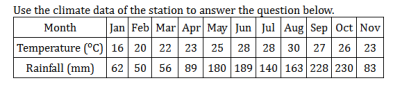
- 44.Which month in the station has the highest rainfall?
- A.July
- B.September
- C.January
- D.October
Show answerHide answer
Answer: D October
- 45.Which of the following are characteristics of most large cities? They I. have large populations II. are administrative centers III. are religious centers IV. are commercial centers
- A.I and III only
- B.II and III only
- C.I and IV only
- D.II and IV only
Show answerHide answer
Answer: C I and IV only
- 46.Which of the following best describes the characteristics of a rural settlement
- A.large area coverage
- B.secondary activities
- C.primary activities
- D.tertiary activities
Show answerHide answer
Answer: C primary activities
- 47.Which of the following criteria is used to classify settlements into rural or urban?
- A.Location
- B.Age
- C.Function
- D.Site
Show answerHide answer
Answer: C Function
- 48.Which of the following currents has a warming influence upon the coast along which it flows?
- A.Benguela current
- B.Labrador current
- C.Canaries current
- D.Mozambique current
Show answerHide answer
Answer: D Mozambique current
- 49.Which of the following distinguishes rotation from revolution?
- A.Revolution causes day and night, while rotation causes season
- B.The earth rotates on its axis while it revolves round the sun on an elliptical orbit
- C.A complete revolution takes 24 hours, while rotation marks a year
- D.Rotation causes variation in the lengths of day and night, while revolution causes rising and falling of tides
Show answerHide answer
Answer: B The earth rotates on its axis while it revolves round the sun on an elliptical orbit
- 50.Which of the following factors is a major boost to tourism? Adequate publicity about natural scenery. Promoting a destination's natural beauty can significantly boost tourism.
- A.Adequate publicity about natural scenery
- B.Higher dependency ratio of the population
- C.Variation in mode of transportation
- D.Variation in mode of transportation
Show answerHide answer
Answer: A Adequate publicity about natural scenery
- 51.Which of the following factors least explains the fast-growing population in Africa?
- A.the education of women
- B.control of diseases
- C.improvement in transportation
- D.decline in death rate
Show answerHide answer
Answer: C improvement in transportation
- 52.Which of the following factors must account for the rapid increase in world population during the twentieth century?
- A.Increasing world production of food
- B.The slave trade was abolished
- C.Death rates have decreased rapidly
- D.Birth rates have increased rapidly
Show answerHide answer
Answer: C Death rates have decreased rapidly
- 53.Which of the following features is associated with the upper course of a river?
- A.Delta
- B.Levee
- C.Meander
- D.Waterfall
Show answerHide answer
Answer: D Waterfall
- 54.Which of the following gradients is the steepest?
- A.1 in 134
- B.1 in 351
- C.1 in 153
- D.1 in 531
Show answerHide answer
Answer: C 1 in 153
- 55.Which of the following has the highest mean annual rainfall?
- A.Lagos
- B.Accra
- C.Freetown
- D.Lome
Show answerHide answer
Answer: C Freetown
- 56.Which of the following is a major environmental problem in heavily industrialized regions?
- A.Accelerated erosion
- B.Frost damage
- C.Water pollution
- D.Acid rain
Show answerHide answer
Answer: D Acid rain
- 57.Which of the following is a wind deposited landforms? Loess is a type of sedimentary deposit formed from wind-blown dust.
- A.Loess
- B.Yardang
- C.Rock pedestal
- D.Deflation hollow
Show answerHide answer
Answer: A Loess
- 58.Which of the following is an important line of longitude?
- A.Arctic Circle
- B.Prime Meridian
- C.Antarctic Circle
- D.Tropic of Cancer
Show answerHide answer
Answer: B Prime Meridian
- 59.Which of the following is not a plantation crop?
- A.Oil palm
- B.Rubber
- C.Rye
- D.Cocoa
Show answerHide answer
Answer: C Rye
- 60.Which of the following is not a process of chemical weathering?
- A.Frost action
- B.Hydrolysis
- C.Oxidation
- D.Carbonation
Show answerHide answer
Answer: A Frost action
- 61.Which of the following lakes owes its origin mainly to faulting?
- A.Lake Superior
- B.Lake Victoria
- C.Lake Malawi
- D.Lake Chad
Show answerHide answer
Answer: C Lake Malawi
- 62.Which of the following landforms is associated with parallel faulting?
- A.Gorge
- B.Inselberg
- C.Dyke
- D.Rift valley
Show answerHide answer
Answer: D Rift valley
- 63.Which of the following most accurately describes the climate of coastal lands which are adjacent to cool ocean currents?
- A.monsoon rainfall pattern
- B.winter rain, summer drought
- C.rain all year round
- D.summer rain, winter drought
Show answerHide answer
Answer: D summer rain, winter drought
- 64.Which of the following pairs of landforms are of desert origin
- A.yardangs and batholiths
- B.zeugens and inselbergs
- C.barchans and tombolos
- D.sandbars and tombolos
Show answerHide answer
Answer: B zeugens and inselbergs
- 65.Which of the following phenomena is not directly related to the rotation of the Earth?
- A.night and day
- B.varying duration of sunshine hours
- C.seasonal changes
- D.unequal solar radiation on the earth's surface
Show answerHide answer
Answer: C seasonal changes
- 66.Which of the following provides the best location for a bakery?
- A.Near a large market for bread
- B.Near a regular source of flour
- C.In an area of cheap labour
- D.Near a source of good clean water
Show answerHide answer
Answer: A Near a large market for bread
- 67.Which of the following statements is true about rainfall in station X?
- A.the rainfall in the station is uniformly distributed over the months
- B.rainfall mainly falls in winter
- C.the rainfall duration is six months
- D.the station has a double maximum rainfall
Show answerHide answer
Answer: D the station has a double maximum rainfall
- 68.Which of the following towns is NOT a pre-colonial town?
- A.Bida
- B.Ilorin
- C.Ibadan
- D.Enugu
Show answerHide answer
Answer: D Enugu
- 69.Which of the following type of agriculture would you expect to find around a big city in an industrial society, such as in Europe?
- A.Dairy farming
- B.Grain farming
- C.Animal husbandry
- D.Fish farming
Show answerHide answer
Answer: A Dairy farming
- 70.Which of the following wave actions is a process of erosion
- A.saltation
- B.traction
- C.hydraulic
- D.suspension
Show answerHide answer
Answer: C hydraulic
- 71.Which of the following zones is the least industrialized in Nigeria?
- A.Port Harcourt-Aba
- B.Lokoja-Ajaokuta
- C.Lagos-Ikeja
- D.Kaduna-Zaria
Show answerHide answer
Answer: B Lokoja-Ajaokuta
- 72.Which one of the following countries has an export trade which is dominated by a single mineral?
- A.Zambia
- B.Central Africa Empire
- C.Kenya
- D.Uganda
Show answerHide answer
Answer: A Zambia
- 73.Which pair of activities would you NOT find in an equatorial climate? 1. Commercial grain farming. 2. rice cultivation. 3. lumbering. 4. plantation agriculture. 5. dry farming
- A.3 and 4
- B.2 and 5
- C.1 and 2
- D.1 and 5
Show answerHide answer
Answer: D 1 and 5
- 74.Which purpose is NOT served by the Kainji Dam?
- A.provision of research facilities
- B.provision of water of domestic use all over Nigeria
- C.provision of fishing facilities
- D.generation of electricity for use all over Nigeria
Show answerHide answer
Answer: C provision of fishing facilities
- 75.Which statement is NOT true of the Middle Belt in Nigeria
- A.The soil is not productive
- B.there are insect pests and disease carriers
- C.the population is sparse
- D.none of the above
Show answerHide answer
Answer: D none of the above
Printing is turned off here to protect the question bank. Get the SmarTest app to study offline.
More free Geography papers
JAMB Geography 1978–2020 is in the app
The latest five years of each paper are free here. The SmarTest app has every year we hold, a worked explanation for each answer, and timed mock exams. It works offline.
Android, Windows, Mac and Linux