Geography past questions: WAEC SSCE 2022
49 objective questions, with answers. Free to read and practise.
Sit this paper
49 questions, one at a time, marked as you go or at the end. No account needed.
- 1.A major cause of rapid population growth rate in Tropical Africa is
- A.improved transport facilities
- B.much pressure on land
- C.malnutrition and diseases
- D.lack of family planning
Show answerHide answer
Answer: D lack of family planning
- 2.A major hindrance to foreign investment in Tropical African countries is
- A.low demand for manufactured goods
- B.inadequate raw materials for industries
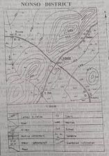
- C.political instability in the countries
- D.inadequate capital for investment
Show answerHide answer
Answer: C political instability in the countries
- 3.A small difference between the readings of the wet and dry bulb thermometers is an indication of
- A.low relative humidity
- B.condensed air
- C.saturated air
- D.high relative humidity
Show answerHide answer
Answer: A low relative humidity
- 4.Figure 1 represents the export of rice by four regions in Country XX in the year 2009. One dot represents 20,000 tonnes of exported rice was used as the scale of the dot map. Study and use the dot map below to answer this question. [img: Open photo] By how much tonnes was the export of rice from region T higher than that from region U?
- A.20,000
- B.40,000
- C.60,000
- D.80,000
Show answerHide answer
Answer: D 80,000
- 5.Figure 1 represents the export of rice by four regions in Country XX in the year 2009. One dot represents 20,000 tonnes of exported rice was used as the scale of the dot map. Study and use the dot map below to answer this question. [img: Open photo] Which region exported the highest tonnes of rice?
- A.R
- B.U
- C.S
- D.T
Show answerHide answer
Answer: A R
- 6.If the map is reduced by half its original size, what would be the scale of the new map?
- A.1:25,000
- B.1:50,000
- C.1:100,000
- D.1:150,000
Show answerHide answer
Answer: C 1:100,000
- 7.If the total population of a country is 75,000,000 and its total land area is 250,000km², what is its population density?
- A.30 persons per km²
- B.300 persons per km²
- C.350 persons per km²
- D.500 persons per km²
Show answerHide answer
Answer: B 300 persons per km²
- 8.In its old stage, a river would I. be interrupted by waterfalls and rapids II. flow sluggishly and develop pronounced meanders III. flow fast and have truncated spurs IV. develop levees and have a flood plain
- A.II and IV only
- B.Il and lIl only
- C.I and II only
- D.Ill and IV only
Show answerHide answer
Answer: A II and IV only
- 9.In Koppens's classification of climates, Cs refers to
- A.Steppe
- B.Mediterranean
- C.Tropical Monsoon
- D.Tropical Continental
Show answerHide answer
Answer: D Tropical Continental
- 10.It is composed of layers of ash and cinders alternating with lava. lt has a broad base and steep convex slopes. The above features are associated with a
- A.batholith
- B.laccolith
- C.shield volcano
- D.composite cone
Show answerHide answer
Answer: D composite cone
- 11.It is crescentic in shape and it is formed from wind deposition in arid. The statement describes
- A.loess
- B.barchan dune
- C.alluvial soil
- D.silty soil
Show answerHide answer
Answer: B barchan dune
- 12.Lines drawn on maps joining places With equal amount of cloud cover are called,
- A.isohyets
- B.isobars
- C.isonephs
- D.contours
Show answerHide answer
Answer: C isonephs
- 13.One of the major problems of manufacturing industries in Tropical Africa is
- A.high quality of the industrial labour
- B.high cost of labour
- C.inadequate raw materials
- D.overproduction of manufactured goods
Show answerHide answer
Answer: C inadequate raw materials
- 14.Study the map of NONSO DISTRICT and use it to answer this question. The commercial centre in the mapped area is
- A.NONSO
- B.Adaku
- C.Bukola
- D.Balu
Show answerHide answer
Answer: A NONSO
- 15.Study the map of NONSO DISTRICT and use it to answer this question. Which of the following settlements is nucleated?
- A.Bukola
- B.Datsu
- C.Adaku
- D.NONSO
Show answerHide answer
Answer: D NONSO
- 16.The best way of solving transportation problems in a cosmopolitan city is
- A.use of air transport system
- B.construction of feeder roads
- C.purchase of many speed boats and ships
- D.integrated transport system involving all modes
Show answerHide answer
Answer: D integrated transport system involving all modes
- 17.The distance as the crow flies from Bukola to Balu is approximately
- A.2.8km
- B.3.8km
- C.4.8km
- D.7.8km
Show answerHide answer
Answer: C 4.8km
- 18.The formation of block mountains are best associated with
- A.accumulation of materials ejected from within the earth's crust
- B.solidification of magma within the earth's crust
- C.uplifting of crustal block within two parallel faults
- D.vertical movement of sediments into geosynclines
Show answerHide answer
Answer: C uplifting of crustal block within two parallel faults
- 19.The growth of NONSO settlement is probably because
- A.NONSO settlement has a court
- B.NONSO is situated at the foot of a ridge
- C.NONSO is a port town
- D.NONSO is a nodal town
Show answerHide answer
Answer: D NONSO is a nodal town
- 20.The highest spot on the mapped area is approximately
- A.1300 metres
- B.1250 metres
- C.1150 metres
- D.1050 metres
Show answerHide answer
Answer: B 1250 metres
- 21.The least important factor in the location of settlements is the availability of
- A.surface water
- B.mineral deposits
- C.land for building
- D.fertile soil
Show answerHide answer
Answer: A surface water
- 22.The most significant factor that led to the revolution in the Japanese industrial sector is the
- A.presence of huge copper mines
- B.existence of vast oil and gas fields
- C.military strength of the countries that aided them
- D.inputs of committed and skillful industrial workforce
Show answerHide answer
Answer: D inputs of committed and skillful industrial workforce
- 23.The movement of the earth that causes variation in the length of the day and night is
- A.traction
- B.revolution
- C.rotation
- D.coriolis
Show answerHide answer
Answer: C rotation
- 24.The sharp pillars hanging from the roof of a cavern in limestone regions are called
- A.dolines
- B.stalagmites
- C.uvalas
- D.Stalactites
Show answerHide answer
Answer: D Stalactites
- 25.The term overpopulation could best be described as a situation where
- A.there is high population density
- B.birth rate is equal to death rate
- C.the population exceeds the available resources
- D.there is an increasing birth rate and a decreasing infant mortality rate
Show answerHide answer
Answer: C the population exceeds the available resources
- 26.The term pyroclastic best describes
- A.sediments accumulated in deep sea
- B.a wind-blown sand from desert regions
- C.eroded materials deposited at the mouth of a river
- D.fragmented materials ejected by volcanoes
Show answerHide answer
Answer: D fragmented materials ejected by volcanoes
- 27.The term relative location of settlement refers to
- A.imaginary point of the settlement
- B.the nature of the buildings within the séttlement
- C.the position of buildings in relation to other buildings
- D.the position of settlements in relation to others
Show answerHide answer
Answer: D the position of settlements in relation to others
- 28.The trade liberalization policy of ECOWAS is aimed at
- A.fostering unity and peace among member states
- B.taking a common stand on the World issues
- C.promoting economic integration
- D.ensuring cultural cooperation
Show answerHide answer
Answer: C promoting economic integration
- 29.The transport system which is most affected by climatic factors is
- A.water transport
- B.rail transport
- C.road transport
- D.air transport
Show answerHide answer
Answer: D air transport
- 30.The type of cloud from which thunderstorms and heavy rain are experienced in the Tropics is
- A.altostratus
- B.cirrus
- C.cumulus
- D.cumulo-nimbus
Show answerHide answer
Answer: D cumulo-nimbus
- 31.The weathering process which is commonly found in limestone regions is
- A.hydrolysis
- B.exfoliation
- C.oxidation
- D.solution
Show answerHide answer
Answer: D solution
- 32.Transportation helps economic development through all the following except the
- A.diffusion of ideas and technology
- B.promotion of national and international trade
- C.movement of people and commodities
- D.distribution of population
Show answerHide answer
Answer: D distribution of population
- 33.Two towns, P and Q, are on the International Date Line and in the same hemisphere. If the distance between the two towns is 444knm and town P Is located on latitude 3°N, on what latitude is town Q located?
- A.10°N
- B.7°N
- C.4°N
- D.1°N
Show answerHide answer
Answer: C 4°N
- 34.watershed in the mapped area is situated
- A.on the plain
- B.along the pass
- C.on spurs
- D.on the ridge
Show answerHide answer
Answer: C on spurs
- 35.What is the contour interval on the mapped area?
- A.50 metres
- B.100 metres
- C.200 metres
- D.300 metres
Show answerHide answer
Answer: B 100 metres
- 36.What is the direction of flow of River Juth?
- A.Northeast
- B.Northwest
- C.Southeast
- D.Southwest
Show answerHide answer
Answer: B Northwest
- 37.What is the scale of the map in statement form?
- A.One centimeter on the map represents ½ kilometer on the ground
- B.One centimeter on the map represents 1 kilometer on the ground
- C.One centimeter on the map represents 2 kilometers on the ground
- D.One centimeter on the map represents 5 kilometers on the ground
Show answerHide answer
Answer: A One centimeter on the map represents ½ kilometer on the ground
- 38.Which of the following climatic features describes the Equatorial climate?
- A.Double maxima rainfall regime
- B.Winter rain, summer drought
- C.Hot and dry throughout the year
- D.Single maximum rainfall regime
Show answerHide answer
Answer: A Double maxima rainfall regime
- 39.Which of the following coastal features is not due to erosion'?
- A.Bay
- B.Cliff
- C.Beach
- D.Arch
Show answerHide answer
Answer: C Beach
- 40.Which of the following is a factor of population growth?
- A.Climate
- B.Relief
- C.Birth rate
- D.Soil fertility
Show answerHide answer
Answer: C Birth rate
- 41.Which of the following is a light industry?
- A.Petroleum industry
- B.Metallurgical industry
- C.Textile industry
- D.Shipbuilding industry
Show answerHide answer
Answer: C Textile industry
- 42.Which of the following is a process of wind erosion?
- A.Deflation
- B.Saltation
- C.Solution
- D.Traction
Show answerHide answer
Answer: A Deflation
- 43.Which of the following is the leading industrial zone in the West African sub-region?
- A.Western industrial zone of Nigeria
- B.Accra-Tema industrial zone of Ghana
- C.Freetown industrial zone of Sierra Leone
- D.Banjul industrial Zone of The Gambia
Show answerHide answer
Answer: B Accra-Tema industrial zone of Ghana
- 44.Which of the following landforms is not associated with an advancing shoreline?
- A.spit
- B.stack
- C.beach
- D.tombolo
Show answerHide answer
Answer: B stack
- 45.Which of the following pairs are characteristics of igneous rocks? They I. are stratified II are metamorphosed rocks III. are crystalline IV. originate from molten magma
- A.I and II only
- B.II and III only
- C.II and IV only
- D.IIl and IV only
Show answerHide answer
Answer: D IIl and IV only
- 46.Which of the following reasons account for the low traffic on rivers in Africa?
- A.Presence of rapids and waterfalls
- B.Only used for fishing
- C.Wide valleys
- D.Change of colour during rainy seas
Show answerHide answer
Answer: A Presence of rapids and waterfalls
- 47.Which of the following statements is not accurate about sea and land breeze?
- A.Air blows from the sea to the land during the day
- B.Air blows from the land to the sea during the night
- C.Land warms up more slowly than the sea during the day
- D.Sea warms up more slowly than the land during the day
Show answerHide answer
Answer: C Land warms up more slowly than the sea during the day
- 48.Which of the following statements, is accurate?
- A.There is a distance of 111km for every 1° of latitudinal difference
- B.A time difference of 4 minutes exists for every 15° of longitude
- C.Any two opposite lines of latitudes make a Great Circle
- D.The sun is overhead at noon at Tropic of Cancer on December 22
Show answerHide answer
Answer: A There is a distance of 111km for every 1° of latitudinal difference
- 49.Which type of mountain is also called the mountain of denudation?
- A.Block mountain
- B.Volcanic mountain
- C.Residual mountain
- D.Fold mountain
Show answerHide answer
Answer: C Residual mountain
Printing is turned off here to protect the question bank. Get the SmarTest app to study offline.
More free Geography papers
WAEC Geography 1988–2020 is in the app
The latest five years of each paper are free here. The SmarTest app has every year we hold, a worked explanation for each answer, and timed mock exams. It works offline.
Android, Windows, Mac and Linux