Geography past questions: WAEC SSCE 2023
43 objective questions, with answers. Free to read and practise.
Sit this paper
43 questions, one at a time, marked as you go or at the end. No account needed.
- 1.A major function performed by rural settlement is
- A.agricultural
- B.industrial
- C.administrative
- D.commercial
Show answerHide answer
Answer: A agricultural
- 2.A smaller range of temperature is recorded along the coast than the continental interior on the same latitudes because of the
- A.moderating influence of the sea
- B.moderating influence of the sea
- C.higher insolation inland
- D.higher evaporation inland
Show answerHide answer
Answer: A moderating influence of the sea
- 3.An isotherm is a line drawn on a map joining places of equal
- A.pressure
- B.cloud cover
- C.temperature
- D.rainfall
Show answerHide answer
Answer: C temperature
- 4.At what stage is River Aboye?
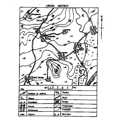
- A.Middle stage
- B.Youthful stage
- C.Initial stage
- D.Mature stage
Show answerHide answer
Answer: B Youthful stage
- 5.Barchan dunes move
- A.at right angle to the prevailing wind
- B.in a circular direction
- C.against the prevailing wind
- D.in the same direction as the prevailing winds
Show answerHide answer
Answer: A at right angle to the prevailing wind
- 6.Buying and selling of goods and services within a country is termed as
- A.foreign trade
- B.international trade
- C.barter trade
- D.internal trade
Show answerHide answer
Answer: D internal trade
- 7.Great Britain and Germany are trading partners of West African countries from
- A.North America
- B.West Europe
- C.South America
- D.The Far East
Show answerHide answer
Answer: B West Europe
- 8.Industries are broadly classified into
- A.primary, secondary and tertiary
- B.mining, furniture making and cocoa processing
- C.fishing, mining and food processing
- D.primary, secondary and manufacturing
Show answerHide answer
Answer: A primary, secondary and tertiary
- 9.More Hydroelectric Power projects should be constructed in Tropical Africa because
- A.there is scanty rainfall
- B.there are absence of waterfalls on rivers
- C.skilled labour is scarce
- D.there is an increasing demand for power
Show answerHide answer
Answer: D there is an increasing demand for power
- 10.Stone crushing is an economic activity at
- A.Noyo
- B.Ameka
- C.Umughara
- D.Agub
Show answerHide answer
Answer: C Umughara
- 11.The area covered by the map is approximately
- A.1400 Km2
- B.900 Km2
- C.1950 Km2
- D.1010 Km2
Show answerHide answer
Answer: D 1010 Km2
- 12.The bearing of Ameka from Aba Omege road junction is approximately
- A.40o
- B.22o
- C.90o
- D.220o
Show answerHide answer
Answer: B 22o
- 13.The distance between Umughara and Ndifu Achara as the crow flies is approximately
- A.8 km
- B.18 km
- C.11 km
- D.23 km
Show answerHide answer
Answer: B 18 km
- 14.The feature marked P in the mapped area can best be described as a
- A.knoll
- B.valley
- C.mountain
- D.ridge
Show answerHide answer
Answer: D ridge
- 15.The instrument used to measure relative humidity is called
- A.hygrometer
- B.anemometer
- C.thermometer
- D.barometer
Show answerHide answer
Answer: A hygrometer
- 16.The likely occupation of the people of Ndifu Achara settlement is
- A.trading
- B.gold mining
- C.rice farming
- D.lumbering
Show answerHide answer
Answer: C rice farming
- 17.The main reason for which most manufacturing industries in West Africa are concentrated in cities and towns along the coast is that they have
- A.a large pool of unskilled labour
- B.large urban market
- C.numerous banks
- D.a large number of warehouses
Show answerHide answer
Answer: B large urban market
- 18.The most common form of migration experienced in countries of Tropical Africa is
- A.urban-urban migration
- B.rural-rural migration
- C.urban-rural migration
- D.rural-urban migration
Show answerHide answer
Answer: D rural-urban migration
- 19.The part of the earth crust covered by water bodies is known as the
- A.sial
- B.stratosphere
- C.atmosphere
- D.hydrosphere
Show answerHide answer
Answer: D hydrosphere
- 20.The scale of the map in Representative Fraction(RF) is
- A.1:25,000
- B.1:100,000
- C.1:200,000
- D.1:50,000
Show answerHide answer
Answer: B 1:100,000
- 21.The sparse population in the middle belt of West Africa can be traced to all the following except
- A.concentration of industries
- B.inter-ethnic war
- C.tsetse fly infestation
- D.Arab slave trade in the north
Show answerHide answer
Answer: A concentration of industries
- 22.The sun is vertically overhead at the tropic of Capricorn on
- A.June 21st
- B.September 23rd
- C.March 21st
- D.December 22nd
Show answerHide answer
Answer: D December 22nd
- 23.The table above shows the temperature and rainfall distribution of station Z. Study and use it to answer questions 11 to 13.

- A.32 oC
- B.10 oC
- C.22 oC
- D.54 oC
Show answerHide answer
Answer: B 10 oC
- 24.The table above shows the temperature and rainfall distribution of station Z. Study and use it to answer questions 11 to 13. The wettest month of the year is
- A.July
- B.September
- C.May
- D.August
Show answerHide answer
Answer: D August
- 25.The type of energy that is most environmentally friendly is
- A.solar
- B.thermal
- C.hydroelectric
- D.nuclear
Show answerHide answer
Answer: A solar
- 26.Town C is located on latitude 15oE while Town D is located on latitude 60oE. If the local time in Town C is 7.00am., what will be the local time in Town D?
- A.4.00 p.m
- B.4.00 a.m
- C.10.00 a.m
- D.10.00 p.m
Show answerHide answer
Answer: C 10.00 a.m
- 27.Under the Greek system of climate classification, the world is divided into
- A.temperate, frigid and hot zones
- B.torrid, equatorial and tropical zones
- C.torrid, temperate and frigid zones
- D.hot, temperate and dry zones
Show answerHide answer
Answer: C torrid, temperate and frigid zones
- 28.Volcanoes that have not erupted for a very long time but may erupt at future time are termed as
- A.extrusive
- B.dormant
- C.intrusive
- D.active
Show answerHide answer
Answer: B dormant
- 29.What is the highest contour line in the mapped area?
- A.400 metres
- B.600 metres
- C.500 metres
- D.300 metres
Show answerHide answer
Answer: C 500 metres
- 30.What is the population density of a country with a total population of 140,000,000 and a total land area of 500,000 km2?
- A.280 persons per km2
- B.200 persons per km2
- C.350 persons per km2
- D.500 persons per km2
Show answerHide answer
Answer: A 280 persons per km2
- 31.Which of the following criteria is used to classify settlements into rural or urban?
- A.Site
- B.Age
- C.Function
- D.Location
Show answerHide answer
Answer: C Function
- 32.Which of the following factors is a major boost to tourism?
- A.Adequate publicity about natural scenery
- B.Variation in mode of transportation
- C.Higher dependency ratio of the population
- D.Specialization in labour force
Show answerHide answer
Answer: A Adequate publicity about natural scenery
- 33.Which of the following features is associated with the upper course of a river?
- A.Levee
- B.Meander
- C.Delta
- D.Waterfall
Show answerHide answer
Answer: D Waterfall
- 34.Which of the following is a feature of heavy industries?
- A.Small scale plants
- B.Low turn-over
- C.Consumer goods production
- D.Capital intensive
Show answerHide answer
Answer: D Capital intensive
- 35.Which of the following is a wind deposited landforms?
- A.Rock pedestal
- B.Yardang
- C.Deflation hollow
- D.Loess
Show answerHide answer
Answer: D Loess
- 36.Which of the following is an important line of longitude?
- A.Antarctic Circle
- B.Arctic Circle
- C.Prime Meridian
- D.Tropic of Cancer
Show answerHide answer
Answer: C Prime Meridian
- 37.Which of the following is not a problem facing transportation development in Tropical Africa?
- A.Climatic variation
- B.Inadequate capital
- C.Difficult terrain
- D.Poor planning
Show answerHide answer
Answer: A Climatic variation
- 38.Which of the following is not a process of chemical weathering?
- A.Frost action
- B.Carbonation
- C.Hydrolysis
- D.Oxidation
Show answerHide answer
Answer: A Frost action
- 39.Which of the following landforms is associated with parallel faulting?
- A.Inselberg
- B.Dyke
- C.Gorge
- D.Rift valley
Show answerHide answer
Answer: D Rift valley
- 40.Which of the following pairs of landforms can be found in the desert areas?
- A.Barchans and tombolos
- B.Yardangs and batholiths
- C.Sandbars and tombolos
- D.Zeugens and rock pedestals
Show answerHide answer
Answer: D Zeugens and rock pedestals
- 41.Which of the following represents the correct sequence in which denudation occurs?
- A.Weathering →Deposition → Erosion
- B.Weathering → Erosion → Deposition
- C.Deposition → Weathering → Erosion
- D.Erosion → Weathering → Deposition
Show answerHide answer
Answer: B Weathering → Erosion → Deposition
- 42.Which of the following rocks is produced by the solidification of magma within the earth crust?
- A.Plutonic rock
- B.Metamorphic rock
- C.Sedimentary rock
- D.Extrusive rock
Show answerHide answer
Answer: A Plutonic rock
- 43.Which of the following towns is not intervisible from Agubia?
- A.ABADA
- B.Nsuba
- C.Ameka
- D.Ndifu Achara
Show answerHide answer
Answer: B Nsuba
Printing is turned off here to protect the question bank. Get the SmarTest app to study offline.
More free Geography papers
WAEC Geography 1988–2020 is in the app
The latest five years of each paper are free here. The SmarTest app has every year we hold, a worked explanation for each answer, and timed mock exams. It works offline.
Android, Windows, Mac and Linux